

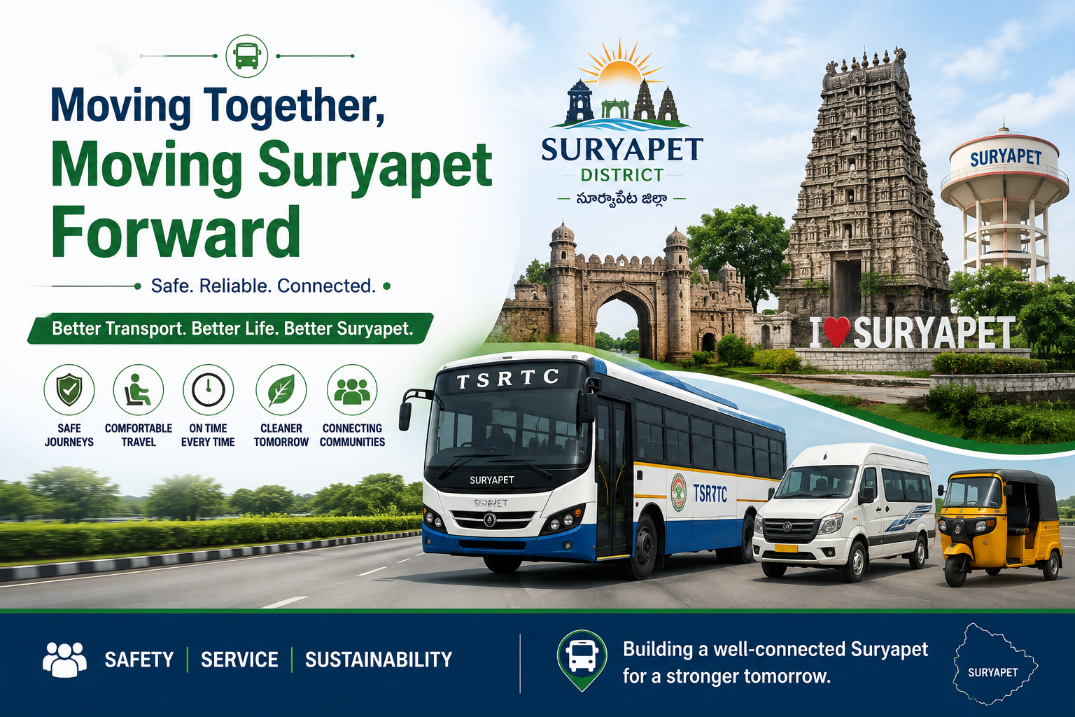
Transport in Suryapet District

By Bus
Suryapet District has a well-connected road transport network, with TSRTC (Telangana State Road Transport Corporation) buses providing regular services to villages, towns, and major cities such as Hyderabad, Vijayawada, Khammam, and Nalgonda.
By Train
Suryapet District is served by nearby railway stations that connect the region to major cities across Telangana and neighboring states. Kodad Railway Station is the primary rail access point for the district, while Mellacheruvu Railway Station also provides passenger services

By Air
Suryapet District does not have an airport. The nearest airport is Rajiv Gandhi International Airport (RGIA), Hyderabad, located about 150 km away. The airport offers domestic and international flights, and it is easily accessible from Suryapet via National Highway 65 (NH-65) by road

Local Transport
Local transportation in Suryapet District is convenient and affordable, with auto-rickshaws, taxis, private cabs, TSRTC local buses, and shared vehicles serving towns and nearby villages. These transport options provide easy access to markets, schools.
Suryapet District – Complete Bus Connectivity Overview
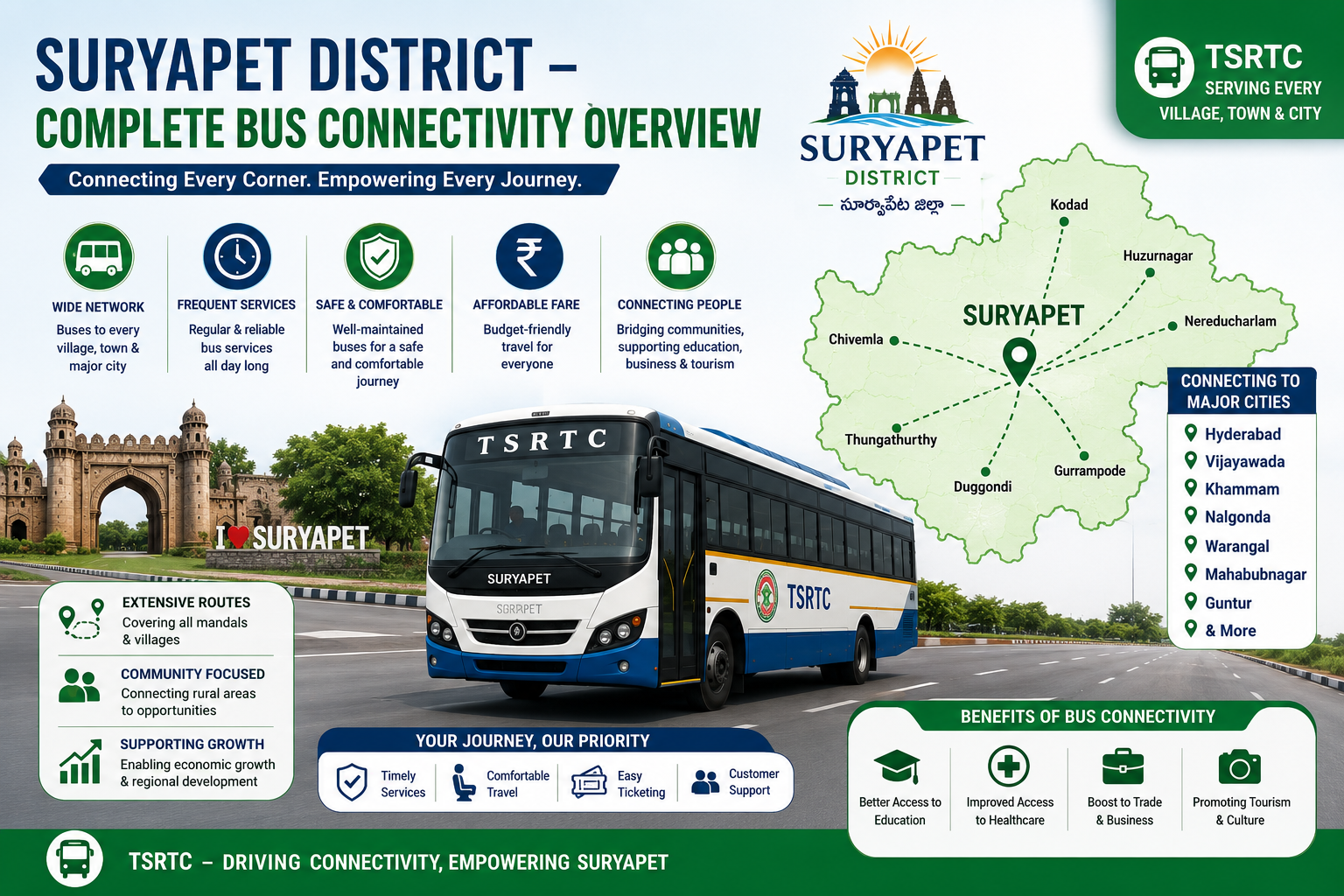
Suryapet District has a strong and well-developed road transportation network that connects every mandal, town, village, and municipality with the district headquarters and neighboring districts, ensuring safe, reliable, and affordable public transport through the Telangana State Road Transport Corporation (TSRTC). The district serves the travel needs of students, employees, farmers, traders, tourists, and daily commuters with frequent and efficient bus services operating across urban and rural areas.
Strategically located on National Highway 65 (NH-65), Suryapet enjoys excellent road connectivity to major destinations including Hyderabad (approximately 135 km), Vijayawada (approximately 135 km), Nalgonda (approximately 55 km), Khammam (approximately 75 km), Miryalaguda (approximately 50 km), Kodad (approximately 45 km), Huzurnagar (approximately 35 km), and Warangal (approximately 110 km). Regular TSRTC services also connect important towns and mandals such as Kodad, Huzurnagar, Chivvemla, Mothey, Nadigudem, Munagala, Penpahad, Mattampally, Mellacheruvu, Thungathurthy, Garidepally, and Suryapet Town, providing seamless transportation throughout the district.
The district’s road infrastructure is supported by National Highways, State Highways, Major District Roads, and an extensive network of rural and village roads, ensuring smooth connectivity between urban centers and remote villages. This comprehensive road network enables efficient movement of passengers and goods while supporting agriculture, trade, education, healthcare, tourism, and industrial development.
The well-connected transportation system provides easy access to educational institutions, hospitals, government offices, markets, commercial centers, and tourist attractions. Regular TSRTC bus services, along with well-maintained roads, ensure comfortable, safe, and convenient travel for residents and visitors alike.
With its strategic location, robust road infrastructure, and dependable public transport network, Suryapet District continues to strengthen regional connectivity and support sustainable economic growth. The district truly reflects the vision of “Well Connected Roads, Stronger Communities,” ensuring that every journey across Suryapet is safe, efficient, and accessible.
Suryapet District – Complete Train Connectivity Overview
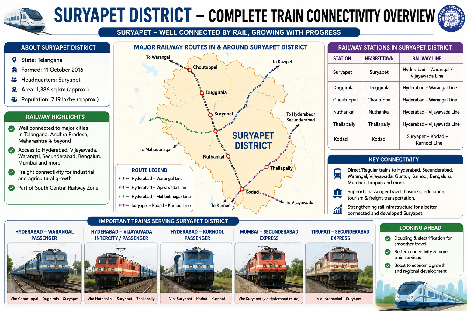
Suryapet District is one of the strategically located districts in Telangana, benefiting from excellent railway connectivity through the busy New Delhi–Chennai (Kazipet–Vijayawada) main railway corridor, one of the most important rail routes in South India. Although the district does not have a major railway junction, its railway stations provide convenient access to several parts of Telangana, Andhra Pradesh, and the rest of India. Operated by the South Central Railway (SCR), the railway network supports passenger and freight transportation, offering safe, affordable, and reliable travel for daily commuters, students, government employees, business professionals, farmers, tourists, and traders. The district’s location between Hyderabad and Vijayawada makes it an important transit region for numerous express, superfast, passenger, and freight trains.
The total railway route length within Suryapet District is approximately 80–90 kilometres, consisting entirely of Broad Gauge (BG) railway lines. The electrified railway infrastructure allows the smooth operation of express trains, passenger services, MEMU trains, and freight trains, ensuring efficient transportation for both long-distance and regional travel. The railway network significantly contributes to the district’s economic development by connecting rural communities with major commercial and administrative centres.
The most important railway corridor serving Suryapet District is the Kazipet–Vijayawada Section of the New Delhi–Chennai Main Line, which connects the district to major destinations including Hyderabad, Secunderabad, Kazipet, Warangal, Khammam, Vijayawada, Chennai, Visakhapatnam, Nagpur, Delhi, Mumbai, Bengaluru, Tirupati, and Kolkata through various direct and connecting train services. This high-density railway corridor carries numerous passenger and freight trains every day, making it one of the busiest rail routes in the country.
Suryapet District is served by several important railway stations, including Kodad, Mothe, and nearby stations such as Madhira, Khammam, and Miryalaguda, which provide convenient access for passengers across the district. Among these, Kodad Railway Station is the principal railway station serving the eastern part of the district, while nearby stations ensure smooth connectivity for residents of surrounding towns and villages. These stations handle passenger services, express train halts, and freight movement, supporting regional transportation needs.
The railway network offers direct or connecting services to many major cities, including Hyderabad, Secunderabad, Warangal, Kazipet, Khammam, Vijayawada, Guntur, Visakhapatnam, Chennai, Bengaluru, Tirupati, Nagpur, Mumbai, Pune, Delhi, Kolkata, and other important destinations across India. These rail services support education, employment, healthcare, business, tourism, and family travel, making railway transportation an essential part of everyday life for the people of Suryapet District.
Rail connectivity also plays a significant role in supporting the district’s agriculture, industries, and commercial activities. Freight trains transport rice, cotton, chilli, maize, cement, fertilizers, construction materials, industrial products, and other agricultural commodities to various parts of the country. The railway network helps reduce transportation costs, improves market access for farmers and industries, and facilitates the movement of raw materials and finished goods, thereby contributing to regional economic growth.
The railway system benefits thousands of daily commuters who travel between Suryapet, Hyderabad, Khammam, Vijayawada, and nearby towns for work, education, business, and government services. Regular express trains, passenger trains, and MEMU services provide economical, reliable, and comfortable transportation, reducing dependence on road travel while improving overall regional mobility.
Overall, the railway network of Suryapet District, with an approximate route length of 80–90 kilometres, serves as an important transportation lifeline for the district. Its broad-gauge electrified infrastructure, strategic location on the New Delhi–Chennai main railway corridor, and excellent connectivity to major cities continue to strengthen economic development, trade, tourism, industrial growth, and public transportation, making Suryapet an important rail-connected district in Telangana.
Suryapet District – Complete Air Connectivity Overview
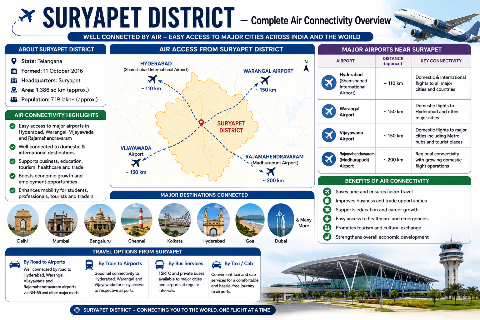
Suryapet District enjoys excellent air connectivity due to its strategic location between Hyderabad and Vijayawada, with easy access to Rajiv Gandhi International Airport (RGIA), Hyderabad, one of India’s busiest international airports. Located approximately 145 km from the district headquarters, RGIA provides seamless access to domestic and international destinations, making air travel convenient for residents, tourists, students, business professionals, and government officials. The airport is easily accessible through National Highway 65 (NH-65), allowing travellers to reach the airport in approximately 2.5 to 3 hours, depending on traffic conditions.
The district is also conveniently connected to Vijayawada International Airport, located approximately 135 km from Suryapet, offering another major gateway for domestic travel. In addition, Warangal Airport (Mamnoor), which is being developed for commercial operations, will further strengthen regional air connectivity in the future. Other airports, including Rajahmundry Airport, Visakhapatnam Airport, and Kempegowda International Airport, Bengaluru, can also be accessed through the district’s excellent road and railway network, providing travellers with multiple air travel options.
The air connectivity of Suryapet plays a vital role in promoting tourism, economic development, healthcare access, education, trade, and industrial investment. Tourists visiting attractions such as Phanigiri Buddhist Heritage Site, Mattapalli Sri Lakshmi Narasimha Swamy Temple, Jan Pahad Saidulu Dargah, Pillalamarri, and other cultural and religious destinations can conveniently reach the district through Hyderabad or Vijayawada airports. Business travellers benefit from quick access to Hyderabad’s IT and industrial corridors, while students and professionals enjoy convenient connectivity to major metropolitan cities across India.
Through Rajiv Gandhi International Airport and Vijayawada International Airport, Suryapet District is connected to all major Indian cities, including Hyderabad, Delhi, Mumbai, Bengaluru, Chennai, Kolkata, Pune, Ahmedabad, Goa, Kochi, Jaipur, Lucknow, Chandigarh, Bhubaneswar, Visakhapatnam, Tirupati, Vijayawada, Nagpur, and many others. These airports also provide direct international connectivity to destinations such as Dubai, Abu Dhabi, Doha, Muscat, Kuwait, Singapore, Bangkok, Kuala Lumpur, London, Frankfurt, and several other global cities, ensuring worldwide accessibility for passengers from the district.
Air connectivity is especially beneficial during medical emergencies, enabling the rapid transportation of patients to advanced healthcare facilities in Hyderabad, Vijayawada, and other major cities. It also supports government administration, disaster management, logistics, cargo movement, and the transportation of essential goods and services. Improved access to air transportation enhances employment opportunities, attracts investments, strengthens tourism, and encourages the growth of the hospitality and service sectors across the district.
Although there is no commercial airport within Suryapet District, its proximity to Rajiv Gandhi International Airport, Hyderabad, and Vijayawada International Airport provides fast, reliable, and efficient access to India’s extensive aviation network. The district also benefits from major national air-route corridors connecting Hyderabad and Vijayawada with important domestic and international flight networks, further enhancing regional connectivity.
Overall, Suryapet District’s excellent air connectivity makes it one of the well-connected districts in Telangana. Supported by nearby international and domestic airports, efficient highway access through NH-65, and extensive domestic and international flight networks, the district continues to strengthen its role as an emerging destination for tourism, education, healthcare, business, investment, and sustainable economic development.
Suryapet District – Complete Local Transport Connectivity Overview
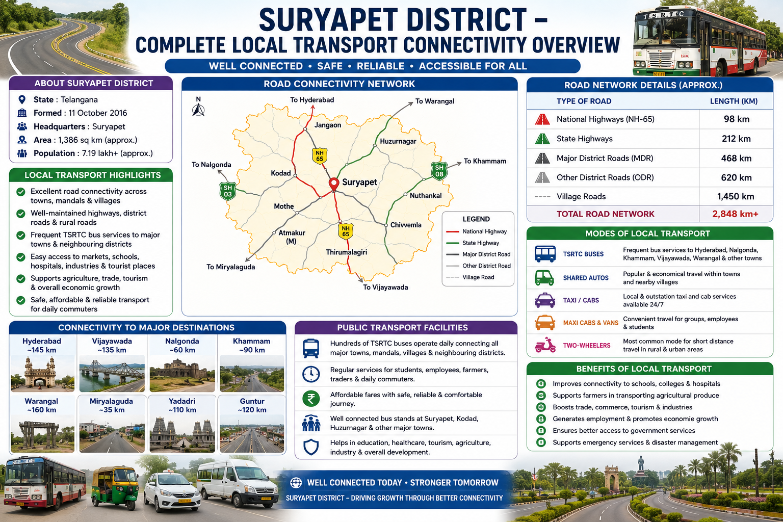
Vikarabad District possesses a comprehensive and well-developed local transport network that ensures seamless connectivity between its towns, mandals, villages, and neighboring districts. The district is served by an extensive system of national highways, state highways, major district roads, rural roads, and village roads, making transportation safe, efficient, and accessible for residents and visitors alike. This well-planned road infrastructure plays a crucial role in supporting daily commuting, trade, education, healthcare, tourism, agriculture, and overall economic development across the district.
The district is strategically connected to Hyderabad, Sangareddy, Rangareddy, Mahabubnagar, Wanaparthy, Kodangal, Tandur, Parigi, Dharur, Pudur, Basheerabad, Kulkacharla, Mominpet, Nawabpet, and other important towns through a network of well-maintained highways and district roads. National Highway 44 (NH-44), India’s longest national highway, passes close to the district and provides excellent connectivity to Hyderabad in the north and Kurnool, Bengaluru, and southern India. National Highway 161 (NH-161) further strengthens regional connectivity by linking Vikarabad with Sangareddy and adjoining districts. State Highways and Major District Roads connect every mandal headquarters, ensuring uninterrupted transportation throughout the district.
Public transportation in Vikarabad is primarily operated by the Telangana State Road Transport Corporation (TGSRTC), which provides frequent and reliable bus services connecting all major towns, villages, educational institutions, hospitals, markets, and government offices. Hundreds of buses operate daily between Vikarabad and Hyderabad, Tandur, Parigi, Kodangal, Mahabubnagar, Sangareddy, Chevella, and several neighboring districts. These services are affordable, safe, and widely used by students, employees, farmers, traders, and tourists.
In addition to bus services, local mobility is supported by a large network of shared auto-rickshaws, private auto-rickshaws, taxis, maxi cabs, vans, and two-wheelers. Shared autos are one of the most popular modes of transport within towns and between nearby villages, offering economical and frequent services throughout the day. Taxi and cab operators provide both local and outstation travel, while school buses and private vans ensure convenient transportation for students and employees. Two-wheelers remain the most commonly used personal vehicles for short-distance travel, especially in rural and semi-urban areas.
The district’s road network includes approximately 121 km of National Highways, 241 km of State Highways, 512 km of Major District Roads, 785 km of Other District Roads, and around 1,650 km of Village Roads, resulting in an overall road network of nearly 3,309 km. This extensive transportation infrastructure connects virtually every habitation within the district, allowing residents to access schools, healthcare facilities, agricultural markets, government offices, and commercial centers with ease.
Local transport plays a vital role in supporting agriculture by enabling farmers to transport crops, dairy products, vegetables, fruits, and other agricultural produce to nearby markets and urban centers. It also facilitates tourism by providing convenient access to popular destinations such as Ananthagiri Hills, Kotepally Reservoir, Borra Caves surroundings, historical temples, forests, and eco-tourism locations. Improved transportation has contributed significantly to employment generation, industrial growth, commercial development, and better access to public services throughout the district.
The district’s transport network also supports emergency services, including ambulance operations, disaster management, police services, and fire and rescue operations. Efficient road connectivity enables faster response during emergencies and improves access to healthcare facilities in Vikarabad, Hyderabad, and neighboring districts. With continued investments in road widening, bridge construction, village road improvements, and public transport modernization, the district is steadily enhancing its transportation infrastructure.